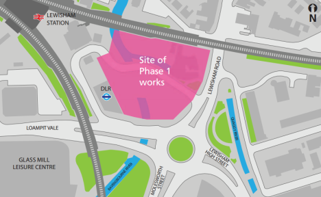
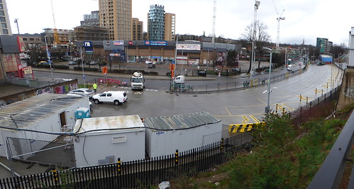
I can’t keep you waiting any longer. Here, obtained from Transport for London via a Freedom of Information request, is the 27-month plan for Lewisham Gateway (as at January 2014):
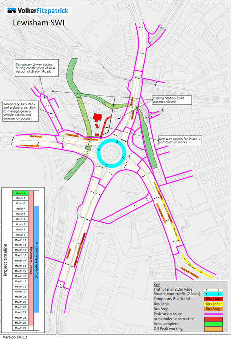
The 27 monthly phases of the Lewisham Gateway highway changes in animated GIF form
That’s an animated GIF, which you can click for a larger-sized version of, but if you prefer to scroll through at your own pace, the full PDF (9MB) is also available here.
So, assuming they stick to these plans and timescales, what can we expect over the next couple of years?
Month 1
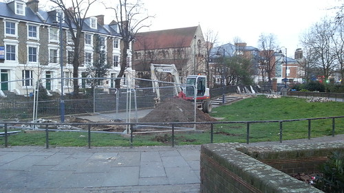
The first thing that’s clear from looking at this document is that we’re not yet at Month 1. Whenever Month 1 finally comes, most of Station Road will be shut – essentially, the entire part you’ll currently find filled with taxis on a Friday night (if you’re not sitting at home blogging about Lewisham Gateway on your Friday night). The remaining straight part of Station Road, between the DLR and platform 2 of Lewisham railway station, becomes a two-way taxi and pick-up/drop-off area.

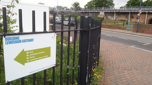
But what’s also particularly striking about Month 1, especially for those of us living near Tesco, is the effect of the work on the available pedestrian routes (that’s the bright pink lines on the maps) to the station. No longer can I walk between the temporary hillocks from Maggie’s to Station Road, then directly along Station Road itself; instead, anyone approaching from that direction will have to walk around the entire building site, past the roundabout, past bus stops C and D and the ghost of stop G, and up the other end of Station Road. If ever there were going to be a time for Southeastern to row back and open up direct access to Platform 4 from the Tesco car park, the first 15 months of this Lewisham Gateway development work should really be it.
The other Month 1 change is the establishment of an entrance for building-site traffic off the roundabout at the eastern end of bus stop D, with an exit from the site into the shut end of Station Road towards Lewisham Road – a couple of points for passing pedestrians to beware of.
Month 2
Month 2 sees the construction of the new routes to be taken by the rivers Quaggy and Ravensbourne, moving their confluence from its current position to the north of (current) Station Road, to its new position in the spot that will become Confluence Place park. It looks like the rivers don’t start flowing along these new routes until…

Month 3
…when the first hint of the blocks of flats which will line the east side of the DLR station begins to appear.
Month 4
The first signs of the road revolution (if that’s not an ironic word for the removal of a roundabout) appear! With the pair of pedestrian crossings you’d use to get from the DLR station to Glass Mill leisure centre relocated to the Glass Mill side of the railway, it’s the beginning of the end for the four snaking roundabout approach islands that until now have necessitated every road to be crossed in two phases by long-suffering pedestrians. They’re converted to “carriageway construction” during this month, with all the associated traffic lights relocated into barrels for manoeuvrability. One island at a time will be worked on “to minimise disruption”. Expect disruption.
Month 5
Goodbye, insignificant Rennell Street! This unassuming dead-end side-road, home of Coffee Addict and the forming-up spot for many a Save Lewisham Hospital march, shuts in its old form, with a short stretch left open for access. The car park there also shuts, and work begins on building pavements and utilities for a bigger, more important Rennell Street: the only link between the east and west sides of Lewisham town centre for general traffic – and the only road for pedestrians to cross when heading to the town centre from the DLR station.

Meanwhile, at the opposite (northern) end of the site, similar work begins on the new Station Road, linking Lewisham Road to the station ticket office area in a straight line next to the railway bridge. The added complication over Rennell Street is that here, the road runs over a currently exposed part of the River Ravensbourne, so there’s bridging to be done.
Speaking of the Ravensbourne, work starts on diverting it further upstream, where the new northern end of Molesworth Street will run.
Month 6
As if they hadn’t got their hands full enough building a whole lot of permanent new roads, at this point the developers have to build a short temporary road, purely for use over the subsequent 16 months. This small kinky diversion will run from the Lewisham Road exit from the roundabout, swing left across that end of what was Lewisham Bus Station, and swerve back to the normal line of Lewisham Road just in time to go under the railway bridge and past Maggie’s. It’s slightly complicated by the fact that this final swerve is across the new end of Station Road; they’ll therefore build this end of Station Road first, excluding its kerbs, so drivers on the temporary road will actually pass over some tarmac which will ultimately be reserved for buses, taxis and bikes.
Over near Glass Mill and Molesworth Street, work begins on building new kerblines and pavements: although Loampit Vale doesn’t move as much as most other roads in the Lewisham Gateway area, there are nevertheless small shifts to be made.
Month 7
Farewell, semicircular park of pigeons and drinkers! You know the one: you could choose to walk through it between the station and the police station, but rarely did. Well, as of Month 7, you never will again.
As the temporary kinky Lewisham Road diversion opens nearby, with bus stops A and B shifted northwards to fit around it, work begins in and around that small park to prepare it to become the new, straight stretch of road linking Lewisham High Street to Lewisham Road. Month 7’s work there includes building new pavements and utilities across the southern half of the park, and constructing some parts of the new culvert through which the Quaggy will flow under the road.
It also appears, from those pink lines again, like this month sees the closure of enough of the pavement opposite the DLR station to prevent its use by pedestrians, meaning that if you wanted to get from Glass Mill to the shopping centre by an approved/safe route, you’d have to do so by crossing three sides of the roundabout instead of one. I suspect this may just be an accidental omission from the map; if not, fortunately it won’t last longer than this one month.
Months 8 and 9
With work well underway on Station Road, Rennell Street and Lewisham High Street/Lewisham Road, that just leaves one side of the Lewisham Gateway road realignment to get stuck into, and Month 8 sees the new northern end of Molesworth Street start in earnest, on top of a section of newly built culvert that’ll guide the Ravensbourne 13 months later.
Month 10
The surviving part of the existing Lewisham High Street (alongside the police station) – basically all of it except the curve round to the roundabout – is resurfaced in readiness for its continuation northwards onto Lewisham Road. This work is expected to take place overnight and will reduce traffic to one lane in each direction while it’s underway.
Interestingly, without explanation, at this point bus stop P by Lewisham Clock Tower appears to split into two, with a built-out pavement reshaping that corner of the road. This is indeed intended to be the final layout but it’s hard to see how the additional stop will be of use at this point, when stop E (opposite the police station) has yet to be removed.

Month 11
One-and-a-half sides of the Lewisham Gateway road network suddenly appear to be complete, construction and surfacing-wise: Rennell Street and Lewisham High Street appear ready for use – aside from the fact that the new bit of Lewisham High Street is a dead end at this point.
Months 12 and 13
Happy developmentiversary! As with Lewisham High Street in Month 10, resurfacing work gets underway on the non-condemned sections of Loampit Vale and Molesworth Street during this month, while construction starts on the final sections of the culvert that’ll carry the River Quaggy under Lewisham Road 11 months later.
Month 14
Speaking of which, in Month 14 work begins on building the new southern end of Lewisham Road to link onto the new northern end of Lewisham High Street – and it doesn’t stop there, either, with pavements rebuilt and reshaped all the way up Lewisham Road to its junction with Blackheath Hill, which by the end of the Lewisham Gateway project is expected to become a mini-roundabout.
Month 15
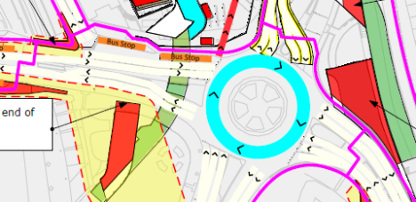
If you enjoyed driving around the southern side of the big Lewisham roundabout, bad luck: not only do you have questionable taste in pastimes but also from Month 15 you’ll never again be able to do so! The gyratory format of the roundabout continues but its south side moves a lot further south, into the new Rennell Street. Essentially, the roundabout which was a small circle becomes a large triangle instead. Traffic is now driving on substantial parts of the new road network, especially the north ends of Molesworth Street and Lewisham High Street, but only in one direction on each.

With traffic now not using the westbound exit from the half-shut roundabout, that space is clear for work to begin on building the next part of culvert that’ll carry the River Ravensbourne under Loampit Vale in seven months’ time.
Month 16
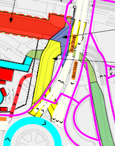
To no small celebratory fanfare from those of us living on the Tesco side of the tracks, the new Station Road opens to traffic and pedestrians, restoring a far shorter walking route to the railway station from Maggie’s – shorter even than now, in fact, as it runs in a straight line all the way from the railway bridge over Lewisham Road. Quite how the “traffic” Station Road is supposedly open to enters the road when bus stop A is still positioned across its entire entry junction for a further eight months is anyone’s guess, though!

The opening of the new end of Station Road means the end which turned two-way and stayed open can return to one-way operation, and do so in a single lane, freeing up half its width for resurfacing.
Months 17, 18, 19 and 20
Bus stops C and D may have lost their shelters in February 2014, but it’s only in Month 17 (and remember, we’re not in Month 1 yet) that the stops themselves finally move out of the way of the work. These two stops join Stop FF (where the 21 and 436 drop off passengers for the station before terminating at the shopping centre) in a close-knit run of three stops alongside Carpetright, all the way up to the corner of Station Road, where they’ll stay for at least four months – I suspect six but the plans suggest they vanish entirely for the last two, which will not be a popular move if true.
Their vacation of their current positions enables the construction there of the final section of culvert for the River Ravensbourne, which will pass under the new public space at the front of the DLR station when it’s complete.
Also in Month 17, the triangular last-gasp roundabout becomes a little more ghostly in shape as its two non-roundabout corners shift slightly onto new bits of road that are now ready, to allow for more work to take place on the bits the triangleabout was routeing traffic across until Month 16.

Month 21
The new River Ravensbourne culvert goes live, carrying the river along a new route, safely out of the way of future blocks of flats planned for the southern part of the Lewisham Gateway site.
This is also the point mentioned above, where it appears stops C and D completely vanish, but there appears to be no reason for this to happen yet so hopefully it’s not the case and these will only go when their replacements open two months later.
As the big moment of traffic routeing switchover approaches, installation of all the new traffic lights gets underway at the various new road junctions around the site.
Month 22
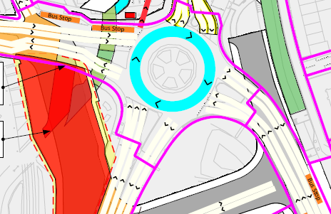
In its final month as any shape of gyratory, the triangleabout becomes a squareabout, now routeing traffic almost entirely along new stretches of road that will form the completed Lewisham Gateway road network (but still in one-way form at this point). Traffic-light installation, road markings and traffic islands are completed, and the developers liaise with TfL and the police to determine a good time for the big switch…

Month 23
It’s happened! The Lewisham Gateway road network is here! Suddenly everything falls into place. The temporary kinky Lewisham Road diversion is wiped out, meaning the new pavements/kerbs can be put in on the corner of Station Road where this previously swerved back towards the road under the railway bridge.
Perhaps most excitingly for bus passengers, a whole new arrangement of stops begins, offering generally convenient interchange and presumably lots of nice new shelters – an improvement in particular when compared with the previous two years’ arrangements! I’ll cover the final bus stop arrangements in a post in the not-too-distant future, because this was the subject of the other document I received from TfL in their response to my FoI request, but for now suffice it to say the current plan is for there to be eight stops serving the Lewisham station/Glass Mill area: six around the east, north and west sides of the central ‘island’ with the DLR station, Confluence Place etc. on it, and two outside/opposite Glass Mill (much as now).

The new River Quaggy culvert opens for business (well, for water) and the old one is closed off – again, this slight rerouteing of the river so it passes under Lewisham Road at a more southern position will make way for the foundations of a planned small block of flats roughly where bus stop B currently stands, opposite the end of the current/old Station Road.
Months 24, 25, 26 and 27
At first glance, these maps, the first of which is simply captioned “SWI [site-wide infrastructure] works complete”, appear to show a period for the developers to stand back, arms folded, smugly nodding at what they’ve achieved and patting themselves on the back. In fairness, that would be understandable if all’s gone well for two years but in fact these few months show them finishing the construction of the two blocks of flats that sit between Confluence Place and the DLR station.
Still, then they can sit back and relax, right? Well, apart from needing to get on with building six further blocks of flats, shops, public spaces and so forth, none of which I’ve yet seen detailed planning applications for, so they might just have a touch more work to do after this epic 27-month transformation process.
And remember, we’re not yet at Month 1.
» Full Lewisham Gateway content archive
Filed under: Buses, Lewisham Gateway, Transport | Tagged: buses, development, Lewisham, Lewisham Gateway, planning, plans, roads, transport | 17 Comments »


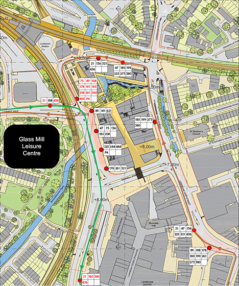
 Perhaps the strangest bus stop that results is the first one on the new Station Road, located very near Maggie’s cafe. This stop will be served by routes which flow northwards from Lewisham on either side of the station area, up Brookmill Road and Lewisham Road, but in opposite directions from each other – four of the six buses at this stop are on their way south (180/199/273/380), while the other two are heading north (47/225)!
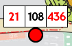 Aside from this the new stops are almost entirely logical and consistent in their grouping of routes, in one case to the point of pedantry: at the stop we currently know as FF, opposite Glass Mill leisure centre, routes 21 and 436 will continue to set down passengers (but not pick up) before terminating behind the shopping centre on Molesworth Street, but they’ll be joined by route 108, which will start its journey to Stratford here. While it may seem strange to mix a first stop with an alighting point in this way, the start of the 108’s route is down Molesworth Street in order to serve the High Street (before heading up Belmont Hill to Blackheath), so these three routes do head off in exactly the same direction from here.
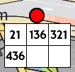 The splitting out of the northbound 47 and 225 from the other routes which head west onto Loampit Vale from the station mentioned above does give the advantage of providing a stop, also on the new stretch of Station Road, at which all four buses (21/136/321/436) share the whole of their next stretch of route, as far as New Cross Gate.
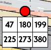
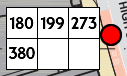 The four buses heading up Lewisham Road (180/199/273/380) stop opposite St. Stephen’s Church (just north of the police station), while the six buses destined for Loampit Vale stop by the entrance to Lewisham Shopping Centre just north of the clock tower.
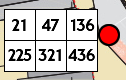 The six buses currently serving stop P, right next to the clock tower, are joined there by the 89, 178 and 261, which all terminate at Lewisham station and wouldn’t otherwise serve the shopping centre, having not come up the High Street.
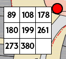 The information provided to me doesn’t mention N-prefixed night buses, but I’d imagine these will mostly share stops with their daytime equivalents. The movement of the 89, and so presumably N89, to share the clock tower stop with the 180 and 199 therefore satisfies a particularly pedantic bit of my brain which has never been happy with the N89 stopping opposite the police station while the 180 and 199 serve the clock tower despite all three of these routes then heading up Lewisham Road.
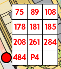 Back up at the station, there’s a huge and clear contrast with the eleven routes terminating at Lewisham station compared to the painful interim arrangements whereby none of them get anywhere near the station itself. Once the work is finished, all these routes – 75, 89, 108, 178, 181, 185, 208, 261, 284, 484 and P4 – will terminate right alongside the DLR station, where the former stop G was – even better than before the work for DLR access, and a tiny bit nearer the railway station entrance too!
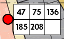 If you want a bus straight down to Catford, you want the second stop away from the DLR entrance, where the 47, 75, 136, 185 or 208 will whisk you directly southwards past our legendary
 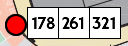 Or if you’re Lee Green-bound, the furthest stop from the DLR entrance, just before the corner with the newly widened Rennell Street, will sort you out with a 178, 261 or 321 bus.
 That just leaves the 89, 181 and 225. The good news for those of us who often catch the 89 is that its stop is closest of all to the DLR station – in fact, an 89 bus picking up passengers will be doing so in almost exactly the same position it does so now, just angled slightly more southerly.
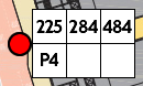 So you’d think the news that the 225 will be joining the three buses the 181 has shared its stop with for years (284/484/P4) would be a time for rejoicing. You’d think that, but it seems TfL’s campaign of maximum trolling of Hither Green residents is set to continue post-Lewisham Gateway: no sooner does the 225 finally move to that stop, than the 181 moves away from it, instead sharing the 89’s stop outside the DLR, which is, er, separated from the 225’s stop by another stop entirely.
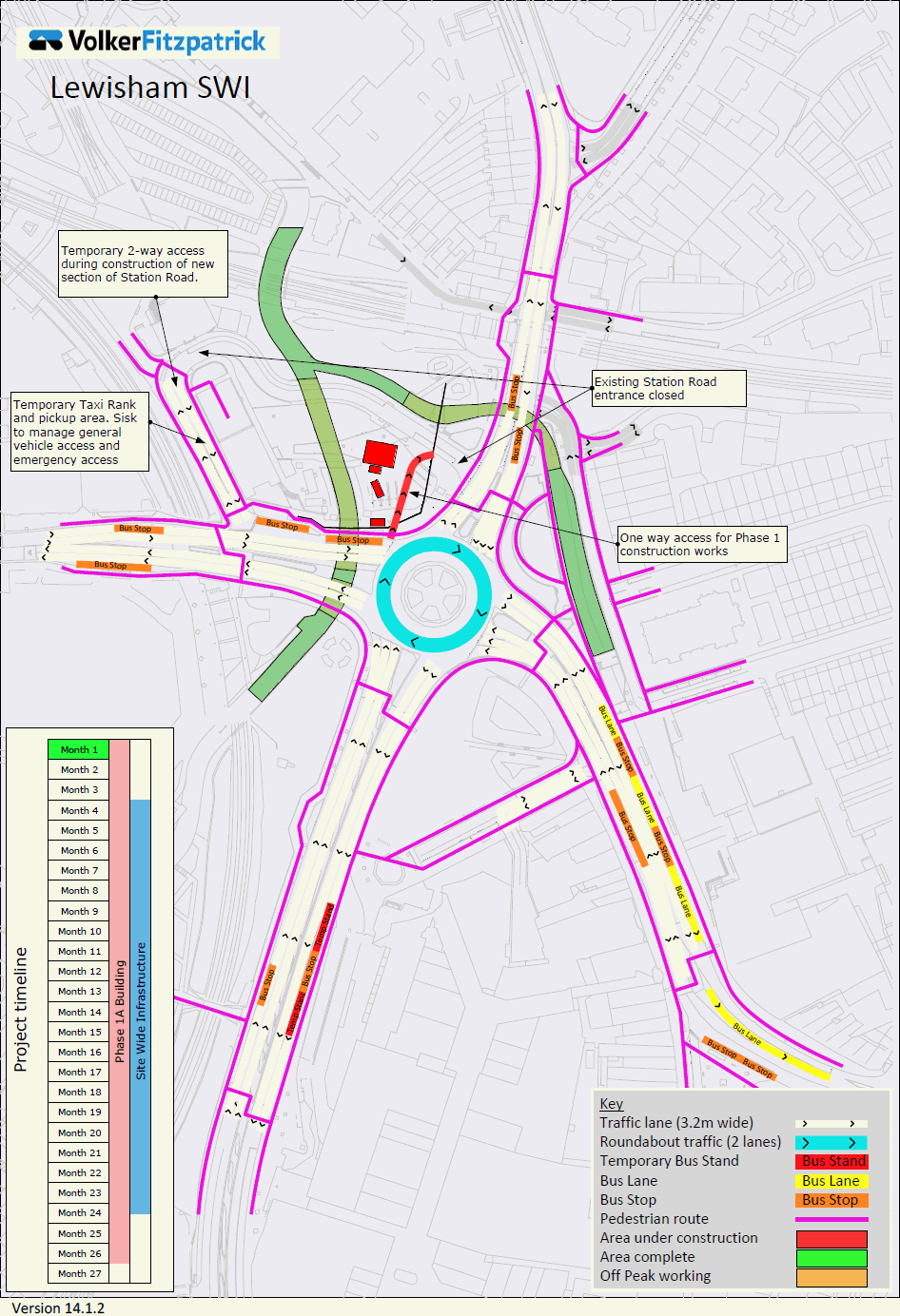


